Could we trade that angle for like, Vancouver? Seems like a fair deal.Minnesota's Northwest Angle (part of Minnesota that can only be accessed by water from the US or by land through Canada) has a fun back story. It exists due to poor maps and a misunderstanding of the source of the Mississippi River at the time:
View attachment 141208
Angle Township was designated as territory of the United States because negotiators of the initial Canada–U.S. border misunderstood the geography of the area. Benjamin Franklin and British representatives relied on the Mitchell Map of colonial American geographer John Mitchell, which did not indicate the source of the Mississippi River—thought to lie some distance to the northwest—or the true shape of Lake of the Woods, which was instead shown as roughly oval. The 1783 Treaty of Paris thus stated that the boundary between U.S. territory and the British possessions to the north would run "...through the Lake of the Woods to the northwesternmost point thereof, and from thence on a due west course to the river Mississippi..."

Northwest Angle - Wikipedia
en.m.wikipedia.org

No forums found...
Site Related
Iowa State
College Sports
General - Non ISU
CF Archive
Install the app
Weird Geography Facts
- Thread starter Al_4_State
- Start date
No forums found...
Site Related
Iowa State
College Sports
General - Non ISU
CF Archive
You are using an out of date browser. It may not display this or other websites correctly.
You should upgrade or use an alternative browser.
You should upgrade or use an alternative browser.
Could we trade that angle for like, Vancouver? Seems like a fair deal.
Why would we trade? We’re getting it all anyways.
KidSilverhair
Well-Known Member
There are six US state capitals further west than Los Angeles.
This is long but super entertaining. From the Youtube history GOAT Oversimplified.Point Roberts Exclave.
Nah. Mexican food is way better than Canadian food. It's their fault that there is pineapple on pizza.You need to allocate more time to the Canadian branch of your international drug cartel.
No. We need to get Bugs Bunny to cut that off.There is also a section of Nebraska east of the Missouri River.
Nah. Mexican food is way better than Canadian food. It's their fault that there is pineapple on pizza.
Plus, Canadians don't know what ham is, They just call it Canadian Bacon but we all know it's Ham
Nah. Mexican food is way better than Canadian food. It's their fault that there is pineapple on pizza.
Poutine is better than a lot of Mexican food. Or in the running, at least.
Ha. I had/have a similar problem with its relation to NJ.Love threads like this. This isn’t unknown or interesting but my dumb brain growing up was under the impression NYC was north of Boston and Connecticut.
Still to this day it doesn’t feel right for some reason.
All 5 boroughs of NYC are (mostly) south of Hackensack, NJ. That seems off on my mental map.
Poutine is delicious, but that is a bold, bold statement.Poutine is better than a lot of Mexican food. Or in the running, at least.
Does it to me worse than mexican food. Must be the grease in the fries.Poutine is better than a lot of Mexican food. Or in the running, at least.
That's hotYou could completely submerge Mount Everest in the Mariana Trench.
View attachment 141174
That melts my brain.
The longest border France has with another country is Brazil.
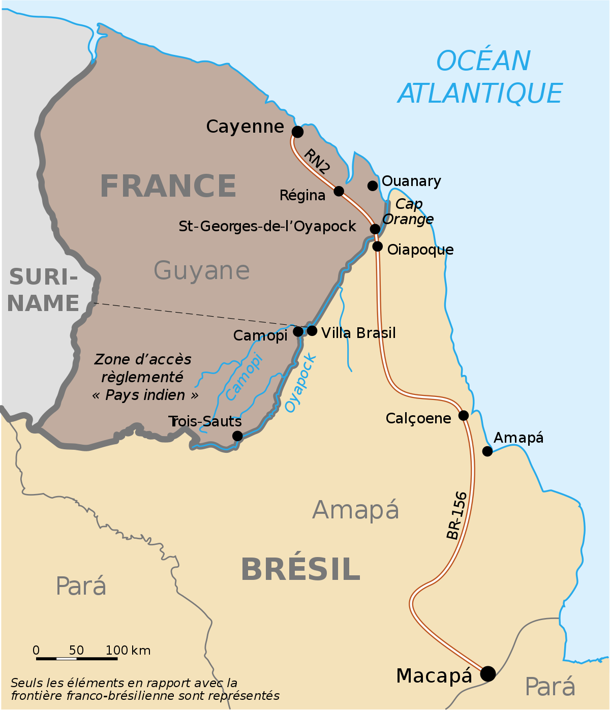
 en.wikipedia.org
Brazil–France border - Wikipedia
Two states share a border with eight states.
Missouri: Arkansas, Illinois, Iowa, Kansas, Kentucky, Nebraska, Oklahoma and Tennessee.
Tennessee: Alabama, Arkansas, Georgia, Kentucky, Mississippi, Missouri, North Carolina and Virginia.
Missouri: Arkansas, Illinois, Iowa, Kansas, Kentucky, Nebraska, Oklahoma and Tennessee.
Tennessee: Alabama, Arkansas, Georgia, Kentucky, Mississippi, Missouri, North Carolina and Virginia.
I don't know if this was mentioned here yet, but the closest point in the lower 48 states to Hawaii is Point Arena in Mendocino County, California, about 120 miles north of San Francisco. NORTHERN California, not southern!
This guy has some good videos on geographical oddities that you'll find interesting if you like this topic.
If all the land in Iowa south of HWY 92 was annexed by Missouri. The average IQ in Iowa and Missouri would increase.
After I used a variation of this to explain to a group the cultural difference between my hometown and that of a coworker from Iowa City, that coworker introduced me to the term “Triangle of Ignorance”.
He said his dad used it to describe the area of Iowa within the triangle formed by three towns I can’t remember (Keokuk, Ottumwa, Burlington?).
He told me his dad used the term all the time, which was somewhat distasteful as his dad is a very high ranking administrator at Iowa.
Last edited:
Every time I hear about Flagstaff my first thought is that Aunt Edna died near there.Last time I drove through Flagstaff it was in a snowstorm. On that same trip coming back we drove through a snowstorm on I-40 that had trucks pulling off the road in Western New Mexico around Gallup. So much for spring break.
Crescent City, CA to San Diego, CA: 848 milesAmes to Dallas … 726 miles
Chicago to New York City … 790 miles
El Paso to Orange, Texas … 856 miles