A lot of that was beans going in.Corn planters went hard two weeks early and now it’s been wet & cold, no corn up. Potential replanting scenario with rain forecast 5 of next 7 days. 3 1/2” rain in March & 4 1/4” in April.
No forums found...
Site Related
Iowa State
College Sports
General - Non ISU
CF Archive
Install the app
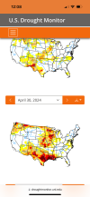
Large Area of Iowa in Extreme Drought.
- Thread starter StClone
- Start date
No forums found...
Site Related
Iowa State
College Sports
General - Non ISU
CF Archive
You are using an out of date browser. It may not display this or other websites correctly.
You should upgrade or use an alternative browser.
You should upgrade or use an alternative browser.
Corn planted around the 12th is up in Story county. Looks pretty good so far. We also missed the rain yesterday.Corn planters went hard two weeks early and now it’s been wet & cold, no corn up. Potential replanting scenario with rain forecast 5 of next 7 days. 3 1/2” rain in March & 4 1/4” in April.
They use a lot of measurements for the drought monitor, including soil moisture and stream gauges. Soil moisture is more short term drought impacts, stream gauges and water table measurements are long term drought impacts. This spring rain will do a lot to address short term, not so much long term.I always thought drought was measured by historical stream and river flows, and had nothing to do with soil moisture. I could also be completely mistaken. Streams and rivers around me in NC Iowa have recovered a little so far . Ponds and lakes are still way down though.
Yes. He was there 3 or 4 years, and was not the first owner.Perpetual motion?
I always thought drought was measured by historical stream and river flows, and had nothing to do with soil moisture. I could also be completely mistaken. Streams and rivers around me in NC Iowa have recovered a little so far . Ponds and lakes are still way down though.
I think all in all this is a better indicator as it tells if water is being pumped into them to fill them up consistently from springs etc.
Local “marsh” is just weeds because river is still so lowI think all in all this is a better indicator as it tells if water is being pumped into them to fill them up consistently from springs etc.
Cedar is still extremely low but approaching average I believe. It doubled from 2' to 4'. Marshes, wetlands and backwaters are still dry/not connected. I heard a rumor of someone fly fishing the roller dam in CR over the winter because you could just wade out.
Very slight change if you use this comparison. Have to select area type to state and then state to Iowa.I don’t think that map changed from last week.
Compare Two Weeks | U.S. Drought Monitor
Compare two U.S. Drought Monitor weeks side by side.
It's valid to April 30th so last rains not included. Next week should show more improvement.
Thanks for sharing the site. Some fun comparison can quickly be run using that site.Very slight change if you use this comparison. Have to select area type to state and then state to Iowa.
Compare Two Weeks | U.S. Drought Monitor
Compare two U.S. Drought Monitor weeks side by side.droughtmonitor.unl.edu
It's valid to April 30th so last rains not included. Next week should show more improvement.
Much of Texas and Louisiana were in extreme to exceptional drought in September 2023. Then El Niño really started to play a role in global weather patterns. Those areas now have no drought just 7-8 months later. It’s amazing how quickly drought conditions can change

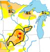
Most of the drought in Iowa currently would be considered long term impacts. They delineate short and long term drought impact areas on the US map on the front page. The fact that Iowa has a black outline with an L in it indicates the majority of impacts that remain are considered long term, and most of the short term impacts are gone due to the wet spring. It's going to take several more months of high, or at least normal, precipitation to get the long term impacts back to normal. If it dries up in June and stays dry the rest of the summer, which is a pattern we've seen fairly frequently lately, we will be right back to where we started the year by fall.


In my area, There are a lot of overflowing rivers, dredge ditches (sump pumps running for a month) standing water in fields, rivers overflowing their banks now. The lakes i go by are at a little above normal levels. They are calling this moderate drought. It is not close to drought conditions here.Most of the drought in Iowa currently would be considered long term impacts. They delineate short and long term drought impact areas on the US map on the front page. The fact that Iowa has a black outline with an L in it indicates the majority of impacts that remain are considered long term, and most of the short term impacts are gone due to the wet spring. It's going to take several more months of high, or at least normal, precipitation to get the long term impacts back to normal. If it dries up in June and stays dry the rest of the summer, which is a pattern we've seen fairly frequently lately, we will be right back to where we started the year by fall.
View attachment 128619
What county do you live in?In my area, There are a lot of overflowing rivers, dredge ditches (sump pumps running for a month) standing water in fields, rivers overflowing their banks now. The lakes i go by are at a little above normal levels. They are calling this moderate drought. It is not close to drought conditions here.
Well your county is right on the margins and has shown a lot of improvement since the start of the year so I wouldn't be surprised to see it drop out soon. I'm not sure what would be keeping your area listed as drought impacted. It could be deep soil moisture measurements or data from shallow aquifers that shows those are still below normal in that area. Those are long term impacts that are going to be difficult for the average person to notice. You'd have to ask the folks in Lincoln who put it together, but I promise they have some reason to keep that area as drought impacted. Plus, as much as they try to be accurate, it's not an exact science and you can't expect the margins of drought affected areas to be exactly accurate.Hancock

