WU is technically still saying a 90% chance, but it's fine from almost an inch projected this morning to under a quarter inch now.Weather channel is saying rain still, overnight, like anticipated all day. Nothing changed from what I am seeing.
No forums found...
Site Related
Iowa State
College Sports
General - Non ISU
CF Archive
Install the app
***Official 2024 Weather Thread***
- Thread starter wxman1
- Start date
No forums found...
Site Related
Iowa State
College Sports
General - Non ISU
CF Archive
You are using an out of date browser. It may not display this or other websites correctly.
You should upgrade or use an alternative browser.
You should upgrade or use an alternative browser.
WU is technically still saying a 90% chance, but it's fine from almost an inch projected this morning to under a quarter inch now.
It could end up right (broken clocks and all) but i swear anytime anyone is in here citing a deviation from what's expected by WU it never pans out.
downtown looked OK on Brandon Copic's stream but some of the residential areas have been hit heavily.I think that town is gone. Just a direct hit.
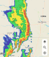
Anyone have an idea if that solid line of storm in west central Iowa is supposed to hold together? Between the derecho and ash borer, we no longer have large trees around us to come down, but that line looks mean if it holds together, regardless.
It's not all gone but it's really bad, Brandon Copic on YouTube is live there right now.I think that town is gone. Just a direct hit.
IMO I think that's because WU actually tries to forecast precipitation totals rather than just precipitation chance. We may end up getting more than the tenth they are saying, but bigger picture is that it's saying the total is trending downward from earlier today.It could end up right (broken clocks and all) but i swear anytime anyone is in here citing a deviation from what's expected by WU it never pans out.
Before the last one, other than it was a good day for tornadoes, I don't believe there was much of an official Warning. See this Tweet about Minden, anticipating what was happening or about to, on the ground, but not yet apparent on the radar:Radar indicated tornado just outside Minden...again. That's terrible if actually on the ground
talks about “pattern recognition.”
I thought maybe it was possibly less visible on radar because it was a wedge tornado:
:max_bytes(150000):strip_icc()/canada-weather-tornado-in-manitoba-595077974-58a0c0253df78c4758017611-dfc314814c60431283a2dcc75451a08a.jpg)
What is a Wedge Tornado?
Explore one of the rarer shapes a tornado can take: that of a wedge. This shape has been linked to the largest and most violent of tornadoes.
From this NWS page, the Minden tornado was classified with the Shelby County one
Tornado Outbreak of April 26, 2024
www.weather.gov
But on that same page it wasn't classified with the Treynor-McClelland one, which was considered dissipated, at about the same time the Minden one formed, also near McClelland.
NWS is completely missing one north of Edmond OK
Did David Payne give it a “News 9 Tornado Warning”?
Below are three YouTube videos of the Minden tornado someone sent to me.
I haven't looked at them for awhile, but the first two are shorter, and the third captures a longer sequence (10 minutes).
I'll add some brief notes from what I recall.
Here is someone driving in from the north, as the tornado hits. I-80 is 2 miles north.
I believe this is south of Minden (and the second part of the video is on Lincoln NE).
This captures more of the entire sequence, but less close up. See more of the shape shifting (on east side, out?, on its way out of Minden?). IIRC might have been driving in from the north, but decided to turn around, maybe some of this is from I-80.
Last edited:
How many Vietnam vets does it take to change a lightbulb?
You wouldn't know. You weren't there.
Boy they nailed this projection. The storm is weakening now that it’s passed Adair but that was impressive.


