Your analogy isn't a very accurate representation of the problem some communities in Iowa are facing. Instead of an empty glass fill it to the top with sand so only a small percentage of the water you try to put into the glass infiltrates and the rest runs off. Then punch a couple of straws into the sand that people are continuously drinking out of. A little more accurate representation there.While it might take a week for a 16 ounce glass of water to evaporate in the summer sun........it only takes a few seconds to fill it up.
Northern Texas in 2015 and California last winter are a testament to that after many seasons of below average rainfall.......just one with above average worked wonders.
Things in Iowa the summer of 92' were pretty dry....................12 months later?
Who knows what will happen this spring in Iowa.

No forums found...
Site Related
Iowa State
College Sports
General - Non ISU
CF Archive
Install the app
***Official 2023 Weather Thread***
- Thread starter wxman1
- Start date
No forums found...
Site Related
Iowa State
College Sports
General - Non ISU
CF Archive
You are using an out of date browser. It may not display this or other websites correctly.
You should upgrade or use an alternative browser.
You should upgrade or use an alternative browser.
Did they all stop using enogen? Several started using that ten years ago or so and that cut their water use drastically.Meanwhile, ethanol production and data centers are consuming water at a record pace.Biggest users by far in Iowa.
For non-irrigated corn, the best I've seen is about 3-4 gallons of water to produce a gallon of ethanol. Those were 2022 numbers.Did they all stop using enogen? Several started using that ten years ago or so and that cut their water use drastically.
In 2022, 4.5 billion gallons of ethanol were produced in Iowa.
Last edited:
I just asked about enogen corn use. Did plants stop using it?For non-irrigated corn, the best I've seen is about 3-4 gallons of water to produce a gallon of ethanol. Those were 2022 numbers.
In 2022, 4.5 billion gallons of ethanol were produced in Iowa.
Only if the farmer's quit growing it.I just asked about enogen corn use. Did plants stop using it?
Huh? The plants decide if they are going to use it or not and then contract. I know some do and some don’t use it. Sounds like you don’t know and are just trying to make things up.Only if the farmer's quit growing it.
What do you grow?Huh? The plants decide if they are going to use it or not and then contract. I know some do and some don’t use it. Sounds like you don’t know and are just trying to make things up.
I like the avoidance. Let’s do some research first. I raise hogs and know that the hog industry (on its own and not including cattle, chickens, and any other meat/milk/egg production) uses more water in Iowa than ethanol.What do you grow?
Yes, Enogen use for ethanol production has decreased dramatically. It is primarily marketed towards cattle feeders now.Did they all stop using enogen? Several started using that ten years ago or so and that cut their water use drastically.
Last edited:
It's WEATHER thread not an ethanol thread. Just stop.
By the same token, where they are recording could be dryer than the surrounding areasProbably because the exact spot of your quarter acre lawn isn't representative of the amount of area the drought monitor is attempting to reflect. Rains have been extremely spotty the past couple of years. In many cases, a distance of a mile could be a difference of four to five inches annual rainfall pretty easily.
Like I told my wife, in some ways a half inch is the same as 5 or 6 inches.Speaking of weather, I am wondering how much snow the .5" of rain i got would have made if it was average temp for late December today and not 39 degrees.
Edit: Found an online calculator which gave me a conversion of 5" - 6" of snow.
By the same token, where they are recording could be dryer than the surrounding areas
The maps and classifications aren't just current soil moisture and rainfall. It's not a statistical model but an interpretation. Thought this from the Drought Monitor web was interesting. Weather (rainfall and temperature) play a big part, obviously, but a lot of other data and observation go into the mapping.
How do we know when we're in a drought?
When you think about drought, you probably think about water—or the lack of it. Precipitation plays a major role in the creation of the Drought Monitor, but the map’s authors consider many data sources. Some of the numeric inputs include precipitation, streamflow, reservoir levels, temperature and evaporative demand, soil moisture and vegetation health. No single piece of evidence tells the full story, and neither do strictly physical indicators. That’s why the USDM isn’t a statistical model; it’s a blend of these physical indicators with drought impacts, field observations and local insight from a network of more than 450 experts. Using many different types of data and reconciling them with expert interpretation is what makes the USDM unique. We call it a convergence of evidence approach.
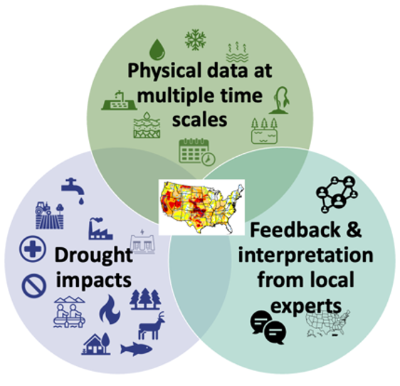
What is the USDM? | U.S. Drought Monitor
A detailed explanation of the U.S. Drought Monitor.
"According to State Climatologist Justin Glisan, last week was the 180th week in a row that certain areas of the state have experienced at least moderate drought.
That’s almost 4 years, making this the longest continuous drought in the state since the 1950s."

 www.kcrg.com
That’s almost 4 years, making this the longest continuous drought in the state since the 1950s."
Iowa farmers still in need of more rain amid ongoing drought
Rainfall over the past few days has provided some relief to the ongoing drought, but Iowa farmers say it isn’t enough.
not a single map lol"According to State Climatologist Justin Glisan, last week was the 180th week in a row that certain areas of the state have experienced at least moderate drought.
That’s almost 4 years, making this the longest continuous drought in the state since the 1950s."
Iowa farmers still in need of more rain amid ongoing drought
Rainfall over the past few days has provided some relief to the ongoing drought, but Iowa farmers say it isn’t enough.

Elwynn Taylor is smiling. He predicted dust bowl for 2025."According to State Climatologist Justin Glisan, last week was the 180th week in a row that certain areas of the state have experienced at least moderate drought.
That’s almost 4 years, making this the longest continuous drought in the state since the 1950s."
Iowa farmers still in need of more rain amid ongoing drought
Rainfall over the past few days has provided some relief to the ongoing drought, but Iowa farmers say it isn’t enough.
No, not really. They have radar data in addition to rain gauges to help interpolate data and get the full picture. Trust me, scientists looking at drought impacts are using a lot more tools and considering a lot more things than people looking out there car window saying "Well things are green in my area".By the same token, where they are recording could be dryer than the surrounding areas